• Cycle Tourism
    • Active & Green
    • Mountains

Gavia Pass by bike

One of the Giro d'Italia's historic climbs straddling the Camonica Valley and Valtellina for road bike enthusiasts

Automatically translated
Where
Passo di Gavia
Ponte di Legno (BS)

The Gavia Pass represents one of the most popular destinations for cyclists from all over Europe.

It was discovered in 1960 by Vincenzo Torriani, who decided to asphalt it and include it in the Giro d'Italia.

Already known since the Middle Ages, the Merchants of the Republic of Venice crossed it to connect to the Via Imperiale d'Alemagna and then reach Germany, the Tyrol and the countries of northern Europe. Many accidents occurred during its crossing, in fact given the constant weather changes, blizzards, avalanches and fog, it was nicknamed the "Deadhead Pass."

It starts from Ponte di Legno (1258 m) to face a climb of about 18 km (the Brescia side is tougher) while instead the Valtellina side with departure from Bormio has a slightly lower average gradient but a good 26 km of the route.

With a charge of energy we set off and up to the 5th-6th km the road is well maintained, wide and with easy gradients until the village of Sant'Apollonia (1584 m). From here the "real" climb begins, the roadway narrows, the gradient more important: the challenge begins.

It continues like this for 3 km, scenic hairpin bends "sweeten" the fatigue and make you appreciate the Valle delle Messi, the climb until a few years ago was not paved and therefore much harder on both arms and legs.

The slopes give a slight respite, the air is cool and light, the sun very warm. You count the meters that separate the road from each bend because taking it "wide" you can breathe for a few seconds: thirst is always lurking and , hairpin bend after hairpin bend, you really sweat a lot.

Past the 14th km, you encounter a tunnel of about 300 m that seems to never end, once you get out you immediately change the ratio and climb at 11% gradient.

The last 3 km to go, you have to grit your teeth, you begin to catch a glimpse of the summit.

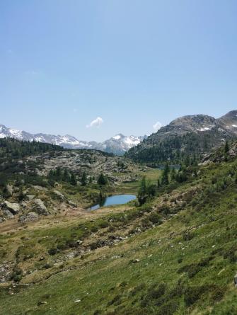
The arrival point is a spectacle: the Val di Gavia (2621 m), just below the Rifugio Bonetta , which with its Lago Bianco makes you admire the alpine panorama.

You catch your breath: this one is done, too!

-

Cover image by Roberto Mantia

Departure : Ponte di Legno (BS)
Finish : Gavia Pass (BS/SO)
Length: mt. 17600
Departure altitude: mt. 1402
Arrival altitude: mt. 2614
Height difference: mt. 1212
Average slope: 6.89 %.

(Source: Grimpeur.co.uk)

Slope Chart

Take me here: Gavia Pass by bike

Places

Fat bike in Val Viola

  • Mountains
Fat bike in Val Viola
7.62 km

Infopoint S. Caterina Valfurva

  • Infopoint
Infopoint S. Caterina Valfurva
7.68 km

Santa Caterina Valfurva

Thirty-five kilometres of slopes for every level of difficulty
  • Mountains
Santa Caterina Valfurva - Parco Nazionale dello Stelvio
7.83 km

Santa Caterina Valfurva lifts

Impeccable facilities in the Stelvio National Park: don't miss the piste dedicated to champion Deborah Compagnoni!
  • Sport
Santa Caterina Valfurva lifts
7.84 km

Ciaspole - Sentiero delle Cappellette

  • Mountains
Ciaspole - Sentiero delle Cappellette
7.84 km

Ponte di Legno

  • Mountains
Ponte di Legno
9.41 km

Infopoint Ponte di Legno

Ponte di Legno and Upper Camonica Valley
  • Infopoint
Infopoint Ponte di Legno
9.47 km

Ponte di Legno

Internationally-renown ski resort in a unique position on the far northern foothills of the province of Brescia
  • Mountains
Ponte di Legno
9.52 km

Ponte di Legno - Tonale Consortium

  • Mountains
Ponte di Legno - Tonale Consortium
10.02 km

Temù black piste

  • Mountains
Temù black piste - comprensorio Ponte di Legno-Passo Tonale
10.02 km

Pista Paradiso Presena

  • Mountains
Pista Paradiso Presena
10.02 km

Sanatorium Museum

Discover in Sondalo the museum that tells the story of sanatoriums built in Valtellina in the 20th century to fight tuberculosis
  • Art & Culture
Sanatorium Museum
11.86 km

Tonale Pass

  • Mountains
Tonale Pass
11.94 km

Sondalo

  • Mountains
Sondalo (SO)
12.28 km

Infopoint Sondalo

  • Infopoint
Sondalo overview
12.35 km

Stelvio Park

Stelvio National Park lies at the heart of the Central Alps and includes typical valleys shaped by the action of ice and water
  • Parks
Parco Nazionale dello Stelvio - inLombardia
13.14 km

Infopoint Alta Valle Camonica

  • Infopoint
Infopoint Alta Valle Camonica - Vezza d'Oglio
13.34 km

Valdisotto Infopoint

Info Point Valdisotto: reception and tourist information in the heart of Alta Valtellina
  • Infopoint
St. Peter's Locality
13.73 km

Where to sleep

RIFUGIO BONETTA

Valfurva
RIFUGIO BONETTA
40 mt

RIFUGIO BERNI

Valfurva
RIFUGIO BERNI
2.02 km

VALMALZA

Ponte di Legno
VALMALZA
2.12 km

RIFUGIO LA BAITA

Sondalo
RIFUGIO LA BAITA
5.5 km

RESIDENZA SOFIA

Ponte di Legno
RESIDENZA SOFIA
6.71 km

DA GIUSY

Ponte di Legno
DA GIUSY
6.78 km

VIKTORIA - DELLE SCUOLE - S.17

PONTE DI LEGNO
VIKTORIA - DELLE SCUOLE - S.17
6.8 km

VIKTORIA - DELLE SCUOLE - S.12

PONTE DI LEGNO
VIKTORIA - DELLE SCUOLE - S.12
6.8 km

VIKTORIA - DELLE SCUOLE - S.19

PONTE DI LEGNO
VIKTORIA - DELLE SCUOLE - S.19
6.8 km

BAITA NINI BIANCA

Ponte di Legno
BAITA NINI BIANCA
6.89 km

THURWIESER

Valfurva
THURWIESER
7.29 km

CHALET BUCANEVE

VALFURVA
CHALET BUCANEVE
7.3 km

VALFURVA RESIDENCE

Valfurva
VALFURVA RESIDENCE
7.32 km

BORMIO STAY - VIA PLAGHERA 3

Valfurva
BORMIO STAY - VIA PLAGHERA 3
7.39 km

SPORT

Valfurva
SPORT
7.55 km

CEVEDALE

Valfurva
CEVEDALE
7.59 km

Al Baitin - Charme & Nature di Compagnoni Giovanna

VALFURVA
Al Baitin - Charme & Nature di Compagnoni Giovanna
7.61 km

Appartamento Sosio Giulio - Via Santa Caterina s43

VALFURVA
Appartamento Sosio Giulio - Via Santa Caterina s43
7.61 km

SANTA CATERINA

Valfurva
SANTA CATERINA
7.63 km

CONFINALE

Valfurva
CONFINALE
7.63 km