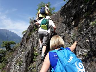
• Active & Green
    • Sport
    • Cycle Tourism

Cycling from Col d'Anzana to Val Fontana

Highest point  2420 m
Total elevation gain 880 m
Total elevation loss 1450 m
Total climb 7,5 km
Total descent 12,7 km
Total distance 20,2 km
Duration 5 - 6 h
Cycling rate (%) 90%

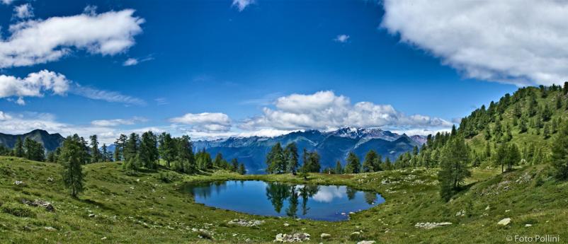
The route runs almost completely on a single trail and, most of all, it is the first stretch of a much longer itinerary, which - once com-pleted - will give the bikers the possibility to start from Switzerland, cycle  all  over  Valtellina  along  the  slopes  of  the  Rhaetian  Alps    at  height and finally arrive to lake Como. The starting point is in Val Saiento, which runs sideways to Valposchiavo in Canton Grisons. you climb up to Col D’Anzana, which marks the line between Italy and  Switzerland,  and  which  can  be  reached  also  from  bianzone,  in  the  Province  of  Sondrio,  through  the  road  going  uphill  to  ne-mina and becoming then a trail that leads to the pass. The start-ing crossway runs along the military track of Sentiero Italia up to Prato  Valentino  and  affords  remarkable  views  southwards  over  Scorcio verso le Orobie dalle Baite Agnè in Val Rogna.   
42Mountain Bikethe mountain chains of the Orobic Alps and of Middle Valtellina. We leave Passo di Meden on our right together with the spurs go-ing down from Monte Combolo and Monte Calighe and reach the ski runs in Teglio from above. The second part of the ride runs deep into the solitary Val Fontana at first and then goes downhill.The start is from the car park in Pescia bassa on a dirt road at 1810 meters above sea level. you go past the Rifugio Anzana (2050 m) and take the well traced trail on your left heading for the pass, but which you can only partly cycle on. From Col D’Anzana (2233 m) you  go  downhill  some  meters  and  find  a  notice  board  with  map  and indications as well as the sign of the Way n. 301. The trail go-ing  around  Monte  Cancano  begins  on  the  right,  then  it  passes  below Passo di Meden (2440 m), reaches Prato Valentino ski runs, and  gets  steeper  below  Dosso  lau  (2020  m)  up  to  Verdomana  (1521  m).  Otherwise  you  can  choose  to  descend  from  Prato  Val-entino  to  Teglio  on  a  road.  but  from  Verdomana  you  turn  to  the  right on a dirt road (sign Way n. 302) through Val Rogna and get to Dalico (1465 m), which is situated on the Costa di San Gaetano along a trail among the woods. We cut across the road climbing from  the  valley  and  –  always  westwards  –  we  turn  into  the  long  sideway on a trail going north and descending to Sant’Antonio in Val Fontana (1253 m), where we take the road leading to the vil-lage of Ponte in Valtellina.


Other links

On the same topic

Lecco from Monte Resegone

Lecco – a city caught between the water and the mountains – is always looking upwards.
Resegone
  • Active & Green

From the metropolis to the province: Milan's top 10 monumental trees

In an area as rich in history as the Metropolitan City of Milan, there is no shortage of valuable green monuments.
  • Active & Green

Teglio walk - Verida - Palama - Ravarola - Teglio

Simple walk through the characteristic rural mid-mountain environment, where cultivated fields, meadows, vineyards and orchards alternate. Depending on the season, typical tellin crops of potatoes, barley, rye and buckwheat can be seen.
  • Active & Green

A green escape in Milan

Parco Sempione, Milano
  • Active & Green

Up and down on a funicular: the panorama seen from the sky

Lombardy funiculars: the most romantic means of transport man has created
Up and down on a funicular: the panorama seen from the sky
  • Active & Green

Under the ground, to discover the caves of Lombardy

On a trip to the caves of Lombardy
Under the ground, to discover the caves of Lombardy
  • Active & Green

The trails of the Oltrepò Pavese

On foot, by bike, or on horseback to discover the Oltrepò Pavese
Comunità Montana Oltrepò Pavese
  • Active & Green

The high route of Valmalenco - presentation

The high route of Valmalenco is a trekking of 8 stage, around 110 km.
  • Active & Green

Suzzara forest

An urban forest in the Municipality of Suzzara, created to recreate an environment typical of the Po Valley of the past.
Suzzara Forest
  • Active & Green

Levadina

Walking in the Levadina Oasis of San Donato Milanese, an opportunity to spend an afternoon immersed in nature.
Levadina
  • Active & Green

9 places surrounded by nature

If you want to spend a day in contact with nature, we recommend these really special destinations.
Discovering Lombardy and its nature
  • Active & Green

Thousand-Year Larch Trail

The oldest tree in Lombardy can be discovered with an unusual hike among the breathtaking views of Valmalenco
Thousand-Year Larch Trail
  • Active & Green

On the wings of winter

In winter at the Parco del Mincio to spot flocks of migratory birds.
The Vallazza Natural Reserve
  • Active & Green

E-bikes in Lombardy

The bicycle is definitely the ideal way to discover an area, thanks to the e-bike, cycling tourism is just within everyone's reach!
Po park bicycle path
  • Active & Green

In Morbegno on the Bridge in the Sky

In Val Tartano, the highest Tibetan Bridge in Europe.
ph. Facebok page Bridge in the Sky
  • Active & Green

Villoresi forest

Come and spend a nice day in the Bosco Villoresi oasis of Carugate!
Villoresi Forest
  • Active & Green

Gardens Bergamo

An unforgettable journey through the wonders of the Bergamo landscape
Gardens Bergamo, the green side of Lombardy
  • Active & Green

Shades of fall - excursions to discover the foliage

  • Active & Green

The unforgettable experience of a mountain hut holiday

Mountain huts in Lombardy: discovering the secrets of the mountains
L’indimenticabile esperienza di una vacanza in rifugio
  • Active & Green

Teglio - Santa Maria - La Piana Promenade

Medium-easy route that winds from fields and chestnut forests to coniferous forests and pastures.
Teglio-Santa Maria-La Piana
  • Active & Green