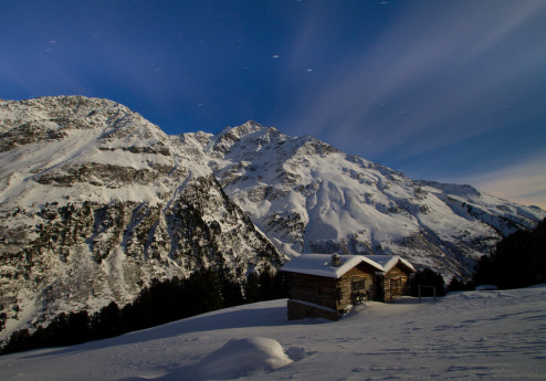
A little bit of Iceland in Valmalenco
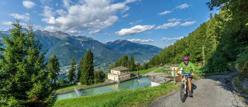
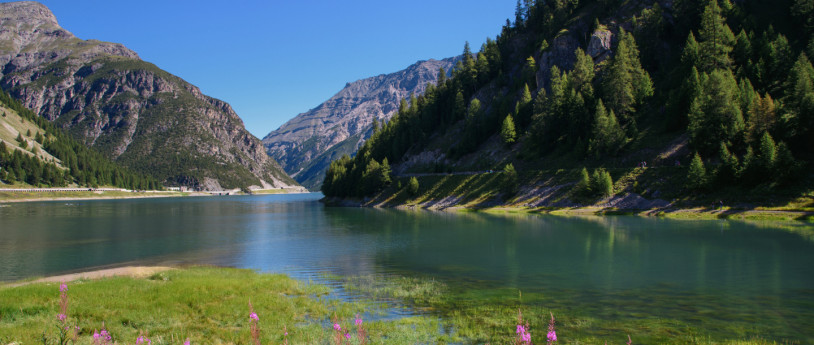
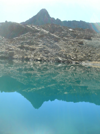
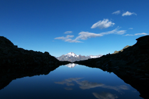
This route is ideal for those who want to escape the unbearable heat of the city in summer and discover small, cool, isolated corners. The trail also allows you to immerse yourself in a unique landscape in Lombardy, with vivid colors in autumn, which cool down as you reach a small Icelandic-looking lagoon, dotted with many small icebergs. In upper Valmalenco, there is a place that recalls distant, cold Nordic scenery: a frozen lake, a black earth beach and an immense frozen cliff; it is the Fellaria glacier that stretches up to an altitude of 3,500 m in the plateau of the same name. It is a constantly changing landscape where it will not be uncommon to witness large breakouts of the lower front or spectacular avalanches and collapses, accompanied by deafening roars from the upper front. As of today, the glacier, following its progressive melting, is divided into two distinct flows, separated from each other by the Sasso Rosso peak: the Fellaria Est (Vedretta Orientale) and the Fellaria Ovest (Vedretta Occidentale).The proposed hike provides a distinct view of the West Tongue and a view of the pond below the East Tongue. The hiking trail has an elevation gain of about 600 m and a duration of approximately 5/6 hours. During its trek it will be possible to admire immense alpine basins, dense larch forests, crystal clear streams and finally the spectacle of the ice giant. This is not a complex trek and technical or exposed points are also completely absent, but a certain amount of training and appropriate clothing is still required. Fortunately for the little ones and those who do not have enough breath, there is the possibility of stopping exactly halfway to stop at Rifugio Bignami, an excellent foothold for the walk and also one of the most scenic places of the entire hike. The trail begins at the base of the Alpe Gera dam; to reach the parking lot, you need to head into upper Valmalenco and then follow the signs for Campo Moro. The last stretch of road (from the village of Lanzada onwards) is quite narrow with many hairpin bends, but the numerous lay-bys still allow two vehicles to pass in opposite directions.If you want to climb in the fall, it is a good idea to inquire about the state of the road by calling Rifugio Poschiavino, Rifugio Zoia or directly at the valley tourist office. Once you reach Campo Moro, the dam and a small reservoir will be clearly evident on the left; on the right stretches a large paid parking lot. This parking lot is about 1 km from the actual start of the hike, but if you arrive late in the morning, it is possible that only this area may still have vacancies. Continuing on the road by car, after passing through a couple of tunnels, you will finally reach the Alpe Gera dam parking lot. The parking lot is unpaved and slightly larger than the previous one. The cost is €6 for the entire day. Bring coins because the machines do not accept cards or bills. In the fall, the last stretch of road and the area directly adjacent to the second parking lot are truly a marvelous sight-the golden larches fill the landscape with color and, dropping their needles, cover part of the roadway. These large orange and yellow flames are everywhere, both on the plain and on the steep slopes of the surrounding mountains, the beautiful contrast created between the warm colors of the forest and the dark rocks of the mountains makes one fall in love with this place. Embellishing the color palette is the sun, which, striking the Campo Moro basin, lights it up with an intense turquoise typical of lakes of glacial origin. After feasting your eyes, you start walking with the goal of reaching the top of the dam. It is possible to continue straight along the fairly steep path that begins at the end of the parking lot, or take the dirt road closed to traffic that leads below the dam wall. The path, after very few meters on the level, immediately veers to the right and continues with fairly steep switchbacks until it reaches the small Enel building located at the base of the dam.Continue on the footbridge located on the side of the dam wall, which in less than 5 minutes allows you to gain the remaining meters of elevation gain and finally reach the top of the Alpe Gera dam.The huge man-made dam seems to separate two completely opposite worlds: on the left, the larch forest traps the beautiful body of water of Campo Moro; on the right, on the other hand, there is a vast basin of water with green and emerald-blue reflections: the Gera Lake. Although being above such a large alpine lake is a peculiar sight (the dam has a capacity of 68 million cubic meters of water), what catches the eye most are the mountains of the Bernina range stretching all around, dominated by Sasso Rosso, Cima Fontana and Sasso Moro.If you sharpen your eyesight, it is also possible to catch a glimpse of Rifugio Bignami, the first destination of our itinerary, in the distance, and just above it, partially covered by clouds, an immense white layer of ice; this is the upper part of Fellaria Est. There are two possibilities to reach Rifugio Bignami: continue along the dam and take the path that faces the ascent on the left of the lake and that in 1h / 1h 30' leads to the refuge, or pass on the right of the lake, reach Alpe Grembé and only then the refuge (1h 30' / 2h).With some time to spare, it is possible to think of tackling one section during the ascent and the other on the return, thus going around the entire lake. However, the proposed route does not have the right-hand variant. Therefore, one continues on the top of the dam until taking the path again, which climbs the side wall of Sasso Moro with a couple of very steep hairpin bends, and then loses a few meters of elevation with a very well maintained stone staircase.The most strenuous part is already behind us, and the remaining 200 m of elevation gain is reached with great ease, continuing along a stretch on an earthy surface with a constant and never excessive gradient. The walking time for this last section is about an hour, but with each step new incredible views of the Gera Basin open up, making it difficult to walk the trail at too brisk a pace.At this altitude the grass still grows lushly and numerous trees manage to cling stubbornly to the rocky slopes of the mountain. The landscape has changing colors that continue to vary due to the constant chasing and hiding of clouds that play with the sun and naturally change from season to season. After numerous photographic pauses, we reach an elevation of 2,389 m on a rocky clearing where Rifugio Bignami stands. The location is truly splendid: a natural balcony that provides a perfect view of the lake and the Fellaria Orientale vedretta.The most striking vantage point where you can admire the glacier is easily identified by a stone cairn and some Tibetan flags.This whole area is called Alpe di Fellaria, one of the highest altitude alpine pastures in Italy (2,400 m). In fact, just beyond the refuge, in a particularly sheltered position, rise a series of small stone huts. Those who want to reach the glacier must take the Luigi Marson Glaciological Trail. A notice board located a few meters from the hut and a large poster placed on the wall next to the entrance door indicate the structure of the next trail.The Glaciological Trail is divided into three parts: A, B and C. Hiking all three variants would take 5 to 6 hours, but to reach the glacier and the small pond, you only need to follow Trail C (about 1h 30'). You then turn left from the hut and start following the wide path that in a few minutes leads to the alpine huts.Once past the small group of buildings, keep to the right until you reach and walk over a small wooden bridge. From here on it is a good idea to pay attention to the signs painted on the rocks or keep a map carefully under hand: the path is in fact indicated by blue markers and no longer by the classic red/white signs. You are now walking in the middle of a large grassy area that allows you to get closer and closer to a majestic rock face. Trail C turning right passes right at the base of this wall, the section to reach punta Marinelli instead climbs above it. Taking a wrong turn at this point could make the hike much longer, so it is necessary to check carefully where the Trail C markers are.Along this section there is also a short section equipped with a chain, placed along the wall to help overcome a small climb. Given the nature of the trail however, one does not feel the need to cling to this support.Once past the climb one reaches a large debris plain. The landscape changes again and the grass now completely gives way to huge moraine boulders and remnants of ancient landslides. The complete absence of vegetation, the cold wind coming from the Eastern Fellaria, and the light snow that is beginning to fall catapult the hiker into a glacial landscape completely different from that observed during the entire ascent. Descending a few dozen meters, one reaches the center of the plain, where a small bridge allows one to cross a stream. Placed at regular intervals, bulletin boards and small plaques now begin to follow one another, indicating the different stages of glacier retreat.Crossing a second bridge and turning westward, it is possible to see the great ice wall of Fellaria Occidentale (2,750 m), located to the left of the Sasso Rosso summit. Since its gradual melting, a very small pond has formed that can be seen by continuing along Trail C. The proposed route does not allow you to get close to the body of water and allows you to observe it only from a distance; however, there are detours to reach it. The section that follows is the most complicated of the entire hike. In fact, the trail climbs over a long expanse of debris until it reaches an elevation of 2,600 m. In this section it is absolutely necessary to follow the trail indicated by the numerous markers, avoiding venturing onto the surrounding rocks, which may be unstable.In about 20 minutes, however, you reach the highest point and can finally admire the Eastern Fellaria Lake, fed by the melt water from the lower part of the glacier and dotted with many small icebergs. This part of the glacier broke off in 2006, going on to create an upper part as high as 2,900 m and a lower part, separated from each other by a long ridge of rock.Over time the lower part receded, going on to form two small lakes that only recently merged into the lake visible today.The glacier in 1850 covered as much as 23 square kilometers, while today it has an area reduced to only 9. For all these reasons the route cannot go beyond this location. Any further approach must be done by carefully assessing the risks and situation of the glacier and taking into consideration that, in case of danger, there is no field in this entire area. As the signs also point out, it is absolutely forbidden to get too close to the low cliff or try to climb the ice. Even standing at arm's length, the spectacle is assured: the high face stands out against the horizon, topping a vertical rock face of almost 250 m, and its frequent collapses draw tongues of snow along the cracks between the rocks, thus going on to create a beautiful contrast of colors. The low ice wall is probably even more incredible, its jagged shapes, the various ice caves carved into it, and the beautiful blue reflections bringing the mind back to landscapes seen only in some distant country. Completing the picture is the lake, literally filled with large chunks of ice continually moved by the light wind and pushed toward the shore where they go to settle and slowly melt, like large diamonds set in the dark sand of the coast.The place is generally very busy, but if you come here off-peak, it will be possible to fully enjoy the sound of the glacier, consisting of long silences and thunderous roars. You may also be lucky enough to see the small groups of ibex that generally roam the shores of the lake. After a long break to take a few photos you are ready to return. The return trail is taken along the same route as the outward journey. No particular changes are noted by walking the trail in reverse: the section with the chain continues to be easily tackled and there are no exposed or dangerous spots.On the way back, given the particularly privileged location and also given the excellent food they serve, it is worth making a stop at Rifugio Bignami. In summer, the outdoor spaces and the balcony are a great vantage point for viewing the lake. In autumn, during a light snowfall, you will instead appreciate much more the warmth of the interior accompanied perhaps by a slice of cake or the "typical dish" consisting of a really generous portion of polenta, sausage and melted cheese.After the break you start your descent again, also the remaining part of the trail is relatively easy and in about 1 hour you reach again the parking lot at the base of the dam. - Ph: Stefano Poma
")