The glacial Forni Valley
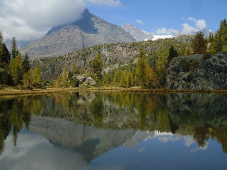
The loop walk proposed here, allows to walk through the entire Forni valley, located in the center of the Ortles - Cevedale group, a valley of glacial origin crossed by the impetuous Frodolfo stream fed by the glacier, whose slopes are carpeted with sparse groves of larches. The spectacle of this place is especially given by the incredible view of the imposing Forni glacier, the largest valley glacier in Italy, which becomes clearly visible already within a few minutes' walk from the parking lot and which makes this place absolutely unique in all the Central Alps. The trail is well marked with several colorful markings on the rocks and plenty of signs placed at the main junctions. Although it is classified as a hiking trail, there are very few complicated sections and, with a little care, it can be hiked by everyone. Although in autumn you may encounter some completely icy sections. For this reason, it is absolutely recommended to check for snow and bring crampons if you plan to tackle the trek from early October onward. After the first substantial snowfall, however, it is recommended to avoid this route, in favor of other easier proposals that have as their starting point the Forni parking lot or directly the village of Santa Caterina. From the village of Santa Caterina in Valfurva, taking the Forni communal road gives access to the Forni valley. The route tackles the ascent along the right slope, then reaches the base of the glacier and the Tibetan bridges placed right where the stream originates. The descent, on the other hand, is along the opposite slope, with the possibility of a stop at the Branca Refuge. The Glaciological Trail is probably the best route to be able to fully experience a hike in such an evocative place. Indeed, in spring the valley is famous for its beautiful blooms and herds of grazing animals; it will also not be rare to see marmots, chamois and stoats. In autumn, on the other hand, the explosion of colors is to be found in the foliage of the many larches scattered at the beginning of the valley. Whichever period you choose, however, the beauty of the glacier and the majesty of the Thirteen Peaks above it will remain the same. To get to the parking lot you have to reach the village of Santa Caterina, where you must purchase a ticket costing 5 euros at the tourist office. In low season and during some working days, however, the rules may change, and at certain times the road may be closed; for this reason it is recommended to contact the village tourist office in advance. From Santa Caterina you take the approximately 4-km-long Forni municipal road, which, although it has some somewhat narrow sections, is nevertheless always paved and well-maintained.At the end of the road you come to a very large dirt parking lot. There are plenty of parking spaces, but in the middle of summer there is always a high influx of people, resulting in the risk of not finding a free space. As soon as you get out of the car you immediately notice the Rifugio Forni, located in an elevated position just a few steps from the highest parking area. It is amazing to think how once upon a time in winter the glacier extended as far as here, actually going to cover the entire valley. Over the past 150 years the gradual retreat of the ice mass has been steady, and since the early 1900s the area has shrunk by 36 percent. As the hike continues, the traces of this sad phenomenon will become increasingly evident. To take the trail, one must reach a large bulletin board located at the end of the parking lot, then turn right and cross the creek; here a sign marks the beginning of the Lower Glaciological Trail (524) and the Upper Glaciological Trail (520), which coincide in the first part. The section now continues along a unique staircase made entirely of rocks and, after a short climb, enters a small grove of larches.In autumn this first part of the trail is quite a sight because of the yellow and orange colors of the grass and tree crowns. Unfortunately, from here it is not yet possible to admire the intense white of the Forni glacier, but even so it is definitely worth stopping for a few shots. The trail continues with a steady but not too challenging ascent to the detour with the High Glaciological Trail. Given the fall season, the proposed section is the Lower Glaciological Trail, both to be able to stay at a lower elevation and to have a better view of the larches, which are completely absent in the higher section. In summer, on the other hand, the choice depends on the time available and the altitude difference you plan to cover. Both paths, however, rejoin after a few kilometers, at the last stretch before reaching the glacier. Turning left you then remain on CAI path 524, which continues at half altitude with several never challenging ups and downs. For long stretches the trail becomes almost flat, allowing you to fully enjoy the walk through the forest. At about 2,250 m the trees begin to give way to classic high mountain vegetation, and it is in this part that the view can finally open up to the incredible beauty of the glacier and the snow-capped peak of Mount Peio. Many small crystalline streams, a sprinkling of snow on the few remaining shrubs and in the distance a huge mass of white ice: these are the glimpses that Valle dei Forni offers. As we continue, the trail moves further and further into the center of the valley until we reach the turnoff for Rifugio Branca (located on the opposite side of the stream). For those who are out of breath there is then the option of ending the ascent to the glacier here and continuing along a much gentler path that leads to the refuge in 30 minutes. For everyone else, my advice is to ignore the sign pointing to the hut and continue going straight ahead, not forgetting, however, a small detour to visit the two small wooden bridges in the middle of the valley that allow you to cross the stream and reach the hut. What begins now is probably the most complex stretch: from an altitude of 2,300 m you have to reach 2,500, along a path that becomes increasingly narrow and with a very rocky and uneven bottom. In autumn several sections unfortunately become covered with ice because of the many streams that run through them. If the ice sheets are not too extensive, it is possible to detour briefly off the trail remaining on drier sections, otherwise it is absolutely necessary to use crampons. To inquire about the status of the trail you can contact the tourist office in Santa Caterina or Bormio. Alternatively, it is possible to access the Branca hut website to view images from the webcam installed on the roof, which frames this very part of the trail. You then continue on a fairly steep section and after a couple of switchbacks you will see the sign indicating the Glaciologico Alto trail.Just after rejoining the High Trail begins what is probably one of the most spectacularly scenic areas of the entire hike. The huge snow-covered rocky peaks are now very close, and around the trail is a landscape rich in moraine debris deposited by the slow action of the glacier. Walking on a stony bottom and overcoming a small landslide, we come to a huge reddish rock formation characterized by a smooth surface full of small concavities where water is deposited; at one time the glacier front reached here and over the years has completely worked the rock face. A little more effort and finally the last stretch of ascent is made. The view now opens to the vast rocky plain at the base of the glacier. Here debris, dark earth and huge iron boulders mingle, creating a messy, almost melancholy, but nevertheless very fascinating landscape. Descending among small cairns of stone, always paying attention to the icy sections, one can now also turn back to the starting point to observe the entire section traversed along the lower part of the Forni Valley. The landscape from here is dominated by the Gran Zebrù massif (3,856 m). From this position the valley appears to be quite anonymous because of the dull colors of the grass, but looking into the distance one can see orange tips: the small forest next to the parking lot. Continuing along the trail, in 5 minutes you reach the first Tibetan bridge that allows you to cross a small stream. The first bridge is only a few meters long and is well secured, while the second bridge is much higher and crosses right over a particularly rushing section of the stream. If you have never walked across a Tibetan bridge walking over it will certainly be quite an experience. The small bridge is entirely enclosed by metal ropes, with which you can hold on to, so there is absolutely no danger. Just before the second bridge, you are right in the middle of the huge depression in the ground created by the action of the glacier; this is probably the best spot to admire it in its entirety. Before this beauty, it is truly impossible to remain indifferent, although astonishment can only soon give way to a certain sense of bitterness: the ice mass has broken shapes, several collapses are evident in the distance, and the nearest front is dirty and covered with debris. Unfortunately, climate change is leaving no escape for this spectacle of nature, and today the Forni glacier no longer exists as a unified mass, but has split into three distinct flows (eastern, western and central) clearly visible from this location, The trail continues straight to the Branca Shelter, but it is still possible to try to get closer to the lower ice tongue. Turning right then, it is possible to walk along an almost level path until reaching a small pond generated by melting ice.Walking along the shoreline of the small body of water, one is fortunate enough to admire the Forni glacier from a truly privileged position, while going around the lake on the right allows one to get even closer. The gradual melting is causing continuous changes in the surface of the glacier: the height of the wall is gradually decreasing, and small caves are constantly being formed and destroyed within it.Therefore, it is absolutely not recommended to try to enter or try to walk over the glacier area unless you are experienced or accompanied by a guide.In general, this entire alternative section should be walked very carefully by carefully assessing the dangers. If you don't feel up to it there is no problem, because the view is still magnificent even from the main trail. After crossing the second bridge, you reach yet another extremely scenic spot on this hike: a small lake that perfectly reflects Mount Gran Zebrù.After a few shots, we resume the descent to Rifugio Branca, where trail 520, after a wide left-hand bend, faces the descent inside a gully. This very short section is quite steep and quite slippery due to the presence of a small river that pours over the rocks. There are no lanyards or chains with which to hold on, so one must proceed with a steady step and be very careful.Once past this somewhat technical section, the trail begins to cut back into the middle of the meadows of the Forni valley and in a very few minutes leads us to the base of Rifugio Branca.The hut is closed in the fall, so it is convenient to consult their website for opening times.In the grassy clearing below the refuge the view is not comparable to that visible from the bridges, but it is still difficult not to stop and admire the view. The trail described now involves descending along trail number 524.This section is actually a wide dirt road used to reach Rifugio Branca by jeep directly from the Rifugio Forni parking lot. The descent then proceeds very expeditiously and without any particular glimpses that are different from the outward journey. Because it is so wide and well-trodden, the road can also be safely traveled at night with a flashlight, perhaps after spending the sunset right at the base of the glacier. In a little more than half an hour in this way the parking lot is reached again. In the summer period it is possible to break the hike in two by stopping for lunch at Rifugio Branca. From September/October, however, the hut is closed, so you will need to bring a packed lunch or decide to eat at the end of the hike right at Rifugio Forni or Rifugio Stella Alpina, located a few kilometers further down the valley along the road from Santa Caterina to the parking lot. - Ph: Stefano Poma


 - Villa Melzi d’Eril")