Ski mountaineering in Val d'Arigna
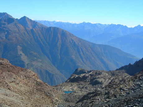
In the locality of Casacce, in Ponte in Valtellina (Sondrio), the not-so-obvious signs indicating the Sazzo-Arigna-Briotti localities should be spotted. One takes the road that leads, through the beautiful Val d'Arigna, to the Armisa power plant. This brings us to the locality of Ca' Pizzini at an altitude of 1,041 meters, where you park your car. With good snowfall you can already put on your skis and set off, following the small road, toward the meadows of the locality Foppe (1,369 m). Here it is worth taking a break and looking around. The landscape that opens up before your eyes offers a view of the most beautiful peaks of the Orobie. Continue now to the Moretti huts (1,456 m) and then to the Campei huts (1,638 m). Upstream of these you must head southeast, crossing a stretch of forest with sparse fir trees that, after about 100 meters of elevation gain, opens into an area dominated by the characteristic "pillow" (snow-covered rocks). One climbs in a northeast direction and enters the obvious little valley on the far left that, keeping face upstream, flows into the hollows adjoining the Pesciӧla hut. It proceeds in a south-southeast direction to an elevation of 1,950 meters. The slope now becomes steeper, and continuing in an easterly direction you climb a small valley that opens up, to the left, at an altitude of 2,000. You thus enter the small valley above and follow it to Pesciӧla Peak (2,344 m), at the watershed between the Arigna and Malgina valleys. You pass it and advance over varied terrain to Faila Peak (2,491 m). Skis are normally left at an elevation of 2,381 m, near a small cross. This is why one should actually speak of Faila lace. Instead, the highest peak can be reached by walking the last steep meters. The descent is made along the ascent route.


")
