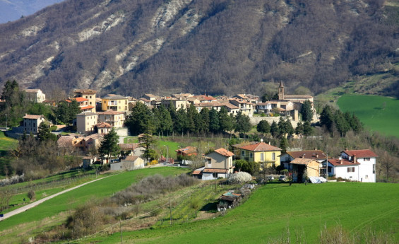
I found 386 results for val di scalve

Cecima

Cecima stands atop a plateau ridge, recognizable by its ancient church rising among the trees. The village has preserved its original medieval appearance, characterized by numerous architectural testimonies. The settlement is traversed by a maze of narrow alleys that intertwine, creating picturesque glimpses. The internal streets are paved with pebbles from the Staffora stream, the same material used for the exposed stone walls of many buildings. Of particular artistic interest are the bastions of the ancient walls, of which only a few ruins remain. Visible traces include the Porta Soprana, demolished in 1936, the now-filled moat, and the castle that once stood at the southwestern end of the village. In the square of the churchyard stands the Parish Church of Saints Martin and Lazarus, rebuilt near the previous 12th-century church, which collapsed due to minor landslides in the early 15th century. It was reconstructed in 1460 in a beautiful late Gothic Lombard style through the patronage of Cardinal Jacopo Ammannati Piccolomini, Bishop of Pavia. However, due to similar geological issues, structural damage appeared over time, leading the Superintendence to order its demolition for safety reasons. The façade, however, was entirely preserved and, thanks to careful restoration work, remains visible in all its splendor today. Inside the church, visitors can admire a precious 15th-century wooden polyptych. The church stands on a magnificent open space, acting as a natural balcony that, with a 200-meter drop, offers a breathtaking panoramic view of Mount Penice, Mount Boglelio, and the Staffora stream. Within the municipal territory lies part of the vast Guardamonte Castelliere, a pre-Roman settlement discovered in 1951 on the ridge between Val Curone and Val Staffora. This significant urban structure has yielded numerous archaeological finds, including artifacts and household items. Photo: Alessandro Vecchi - Own work, CC BY-SA 3.0  

From Montalto Pavese to Trebecco lake

A long route with continuous ups and downs that starts from Montalto Pavese, climbs to Belvedere, and then passes through Montù Berchielli, Pometo, Passo del Carmine, Ruino, and finally reaches Lago Trebecco in the province of Piacenza. SIGNAGE: 201 Montalto Pavese is located in the lower area of the Oltrepò Pavese Mountain Community, south of Pavia, on the valley of the Ghiaia stream. It is called the "queen of Oltrepò Pavese" for its dominant position on the first hills above Casteggio, its beautiful castle with Italian-style gardens, and its wine production. The Belvedere area, located on the ridge of a hill and exposed to strong winds, is a popular destination for tourists and enthusiasts of paragliding and model aircraft. Shortly after Belvedere, following the yellow bicycle sign leading to the unmistakable Big Bench of Montalto Pavese, you can enjoy a breathtaking view of the surrounding hills. After passing the giant bench, from which the Montalto Pavese castle can be seen, you enter a wild area with no trees, where, with a bit of luck, you may encounter some roe deer. The route continues up and down hills and vineyards until reaching Passo del Carmine, located at around 600 meters above sea level in the municipality of Colli Verdi, an important crossroads, as it is at the start of several valleys. Passo del Carmine also represents another important boundary, between the mountainous Oltrepò and the wine-producing Oltrepò, with the first located south of the pass and the second to the north. From the pass, the route proceeds towards Ruino, which was part of the lands of the Monastery of San Colombano during the Lombard period, then descends directly into the Val Tidone, right in line with the Molato Dam that forms Lake Trebecco. The Molato Dam, built between 1921 and 1928, is located in that part of the province of Piacenza where the Val Tidone opens towards the Po Valley and acts as a barrier to the Tidone stream, creating the compensation reservoir known as Lake Trebecco, which has a usable volume of 8 million cubic meters of water.

Chiesa valmalenco

Church Valmalenco or as they call the Valtellina: the Sèsa, is a leading ski resort in Lombardy.
Chiesa Valmalenco - Adobestock

Parco delle Orobie della Valtellina

A nature park just waiting to be discovered on long hikes or on the saddle of a mountain bike
Il parco delle Orobie

From the Orobie to the Crema area

Wonderful cycle paths between art treasures, castles, villages and bridges. 9 stops between the Orobie and the Crema area

Terraces and breath-taking views in Lombardy

Scopri la lombardia attraverso i suoi meravigliosi panorami.
Terrazze e panorami mozzafiato in Lombardia

Seven hamlets to discover in Lombardy

Fortunago (PV)

Walking tour through Menaggio

Historical itinerary along the main sites of the town
Piazza Garibaldi

In the silence of the forest, among firs and larches

Santa Caterina Valfurva is one of the towns within the Stelvio National Park and preserves, as much in its buildings as in its traditions, its alpine spirit. Located at the southern apex of Valfurva, on the border with Val di Gavia, it can be reached by car by heading toward Bormio and then following the signs for Santa Caterina, which is only 13 km from the latter.At the beginning of the village there is a large multi-level parking lot where it is advisable to leave the car since, especially in high season, it is difficult to park in the center. You have to head towards the center of the village and in a little more than three hundred meters you are in front of the Church of St. Catherine, cross the road, walk along a section of Via Frodolfo, until you reach the junction on the left with Via delle Cappellette, where a sign tells you the direction for a nice walk. The route is easy and suitable for everyone, the slopes are gentle and the views are really picturesque and relaxing. Only in the final stretch, where the descent becomes a bit steeper, you have to be careful of possible icy sections in cold weather. The beginning of the trail is a gentle ascent that passes behind the first huts on the slope, you walk it quietly until a hairpin bend where there is a votive chapel. You ascend to the right and the view opens up to the mountains on the opposite slope on whose slopes are the ski slopes, far more crowded and chaotic than this trail. This area, in fact, leads into the quietest and least frequented part of the village, passing through quiet forests and some typically alpine huts, whose perfectly set dark beams recall an ancient knowledge now lost.Continuing further one passes first the small cluster of Sell huts and then, at the end of a winding, gentle climb, the Tov hut next to which one can admire an old hand-carved wooden crucifix. In this section it is the view of Mount Sobretta, to the right, that dominates the scene with its 3,296 m height and rocky, rugged summit. Further on, the view opens to the center of Santa Caterina Valfurva, the historic ski slope dedicated to champion Deborah Compagnoni, and the mountains above the Gavia Pass. Standing out above them all are the pinnacles of the Giumella mountains, Punta San Matteo, Punta Pedranzini and Pizzo Tresero, all abundantly above 3,000 m watching over the valley like ancient frowning giants. After finishing the flat section halfway up, a hairpin bend leads downhill where the final section begins. The gradient is initially undemanding but increases as you descend toward the village, remaining pleasant, however. Here you will find a fork along the descent but it does not matter which way you choose to go since a little further on the two paths cross again, the advice is to take the gentler though longer one on the right. The walk in this section runs through fir and larch forests leaving room for a few fleeting glimpses of the mountains, you are then surrounded by quiet, a walk in the sign of total relaxation. However, the smells of hotel kitchens and the cackling of people gradually get louder once the descent is over and you find yourself on the road that passes in front of the historic Albergo Compagnoni where the loop trail ends.
In the silence of the forest, among firs and larches

6 Interactive museums for children

Explore Lombardy with your children! Experiential and interactive museums to stimulate curiosity and creativity.

Milan-Cortina 2026 Winter Olympics

An event that looks to the future, sustainability and inclusion, immersed in the charm of the Lombard landscape and tradition.

The cavallera road of the Muretto

An ancient alpine connecting corridor, a transit route for goods, people and culture