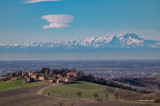
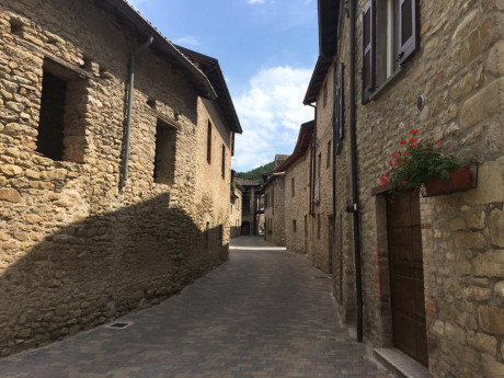
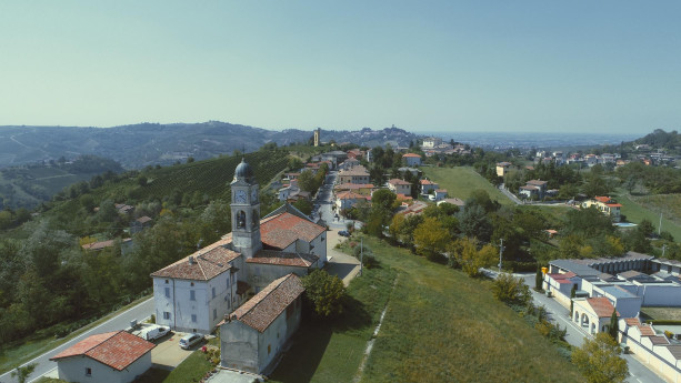
I found 453 results for Borghi

Parona

A small center of Lomellina, located between the territories of Vigevano, Mortara, and Cilavegna, Parona has about 2,000 inhabitants, spread over an area of 9.34 km² at an altitude of 113 meters above sea level (click here for the map of the town center). Parona is an ancient village that has transformed in just a few years from a rustic and somewhat "old" town into a modern, dynamic, and welcoming municipality. Over the years, the town’s economy has gradually changed: from being an agricultural center, it has slowly become a town of small artisans and entrepreneurs, as well as a residential area for the many workers employed in nearby Lomellina towns. Parona is redefining its identity, yet it remains a small, human-sized town immersed in countryside that creates ever-changing and charming landscapes, with unique features that deserve to be discovered. Notable is the Parish Church, dedicated to St. Peter the Apostle, rich in valuable frescoes. In the altar of the Madonna, within a beautiful golden wooden urn, there is a 1700s wax figure of the Baby Jesus (pictured here in a Christmas exhibition). This figure was placed in the Basilica of the Nativity in Bethlehem and laid down on Christmas Eve in the very spot where the shepherds worshipped the celestial infant. The church also houses the majestic painting "Tibi dabo claves" by the painter from Parona, Lorenzo Toma. The same artist created the fourteen panels of the Stations of the Cross along the central nave. Also characteristic is the Church of San Siro, no longer used for religious services, whose bell tower (pictured above) is considered a symbol of Parona, having been chosen as the emblem depicted on the packaging of the "Offelle di Parona." Parona also once had a Castle, home to several feudal families, of which little remains today. Among the notable architectural works, Piazza Nuova stands out (pictured here); inaugurated in 1989, it gave a new look to the town center. Despite these changes, the marks of Parona's rural past are still evident, reminding us of a not-so-distant time when daily life was hard but simple and genuine, with traditions passed down from father to son, of which the religious aspect was essential. A common thread that connected everyone was the language, the dialect, spoken by everyone, from the elderly to the children; this dialect is now almost extinct among the younger generations. To discover the rural past of the town, it may be interesting to visit the eastern part, where traces of Parona's rural world can be found, starting with the Santo Spirito mill, followed by nearby farms still in operation: the Cascina Castello, also called "Cascinino," and the Cascina Scocchellina (pictured), named after archaeological finds, "cocci," in the surrounding area. There is also Cascina Scoglio, which houses several marble sculptures inspired by rural mythology from the late 1920s, as well as frescoes depicting the four seasons. Along the state road to Vigevano, there's Cascina Naïna, now a restaurant, where, in addition to the decorations on the buildings, the chimneys are very similar to those in Vigevano’s Piazza Ducale. The traditional culinary aspects of the area are harder to find, although in recent decades, both in Parona, with the now-famous Sagra dell'Offella, and in other Lomellina towns, various events are held to rediscover and protect typical local products. From an environmental perspective, noteworthy are the Acqualunga Forest with the nearby Newborn Park and the Rampi Forest. In addition to the already mentioned Lorenzo Toma, there are other notable figures who were benefactors of our community in the 19th century and have linked their names to part of the history of our small town. Culturally, several literary works by local authors are worth mentioning: some research on our village by historians Mario Rampi and Angelo Gravanaldi, two poetry collections by Lino Negri and Paola Bellavite, a fairy tale published by Carla Masutti, and a publication for children ("Il mio paese") published by the Pro Loco, which every year donates copies to the children in their first year of elementary school. The municipal historical archive has also been fully restored. Finally, we cannot overlook the events organized by our Pro Loco throughout the year, first and foremost the aforementioned "Sagra dell'Offella" on the first weekend of October, whose first edition dates back to 1969. More recent, but equally attractive, are two other major events: "Parona téra böna," held on the first Sunday after Easter, and "Un paese per giocare," on June 2. The latest event organized by Pro Loco is a grand "Treasure Hunt." (Source: Proloco Parona www.parona-lomellina.it) Photo: Alessandro Vecchi / CC BY-SA (https://creativecommons.org/licenses/by-sa/3.0)

Olevano di Lomellina

Olevano di Lomellina is a small municipality in the province of Pavia, located in the region known as Lomellina, between the Po, Sesia, and Ticino rivers. It is a town with ancient origins, whose existence has always been tied to agriculture, which still remains the main activity today. The vast plain of Lomellina, where Olevano stands, stretches between the Ticino, Po, and Sesia rivers: "a strange, unsettling, and fascinating land that offers visitors vast spaces, great silences, and wide horizons, so rare in Italy." Here, everything has been built, transformed, and organized by man with infinite and centuries-old patience; by nature, this land of springs would be an impassable swamp: and indeed, it was such for centuries. Then, the monastic communities in the Middle Ages, the feudal colonization in the 1200s, and the great agronomic reforms introduced by the Sforza family, who experimented with rice cultivation in the second half of the 15th century, turned Lomellina into a mosaic of rich cereal fields. To serve this vast cultivation, a complex system of canals and ditches was organized, and typical closed-court farmhouses, characteristic settlements of industrialized agriculture in the Po Valley, were built. Today, the laborious cycle of rice cultivation, based on transplanting and cleaning the grain by the rice women (mondine), in fields previously planted with forage, with continuous crop rotation, is just a memory; fertilizers, herbicides, and mechanical means have greatly simplified the work cycle, which begins in April with leveling, flooding, and sowing the rice directly in the rice paddies, and ends in September with the harvesting, threshing, and drying of the grain. Even though the "singing" rice women have disappeared and the number of croaking frogs has greatly decreased, the Lomellina region still retains a fascinating, discreet charm in its vast, deep, and mysterious spaces, scattered between sky and water. In 2018, the Museum of Art and Agricultural Traditions was inaugurated. It collects the most significant objects from the Lomellina agricultural world from the 1800s to the 1960s. It is housed in a renovated rural building, once used as a stable and hayloft, located on Via Uberto de' Olevano, in front of the Medieval Castle. On August 15 and 16, during the feast of Saint Roch, the Sagra del Salam dla Duja is held, featuring the typical pork salami preserved under fat in terracotta pots. "La duja" is a clay pot in which salamis, made with pork, salt, and pepper, are dried and aged for about a month before being placed in the pot and covered with lard. SOURCE: MUNICIPALITY OF OLEVANO DI LOMELLINA Photo:  Solaxart - Preboggion - Milano 

Gravellona Lomellina

Town of Art, Nature, and Imagination

Rosasco

The municipality of Rosasco is located in the western Lomellina, not far from the left bank of the Sesia River. In Rosasco, rice cultivation gives its peculiar characteristics to a rural world that has written and continues to write the history of this territory. The environmental geography is therefore formed by a single morphological area, following a pattern in which the vast countryside is flat and uniform, with a dense network of ditches and canals delimiting the fields and various properties. The advantages derived from a rational distribution and use of water are accompanied by those provided by new, increasingly efficient and sophisticated machines: the farmer has reached excellent production levels thanks to the intense mechanization and modernization of his farms, acquiring entrepreneurial and technological skills that allow him to maintain a high competitive capacity. The generational turnover has seen young farmers increasingly focused on innovation and experimentation. The "Cerchiara"It is a vast swampy basin, extending over about 20 hectares in the territory of Rosasco and an equally large area in the nearby locality of Celpenchio, from which the heronry takes its name. The heronry represents a splendid and unspoiled natural park, where, alongside the lush variety of plant life, numerous species of birds and other animals can enjoy an extraordinary habitat with guaranteed hospitality. The Castle of RosascoBuilt towards the end of the 9th century, the Castle of Rosasco is one of the oldest military structures in Lomellina. It is a vast fortified system, still recognizable in its perimeter, although it suffered a severe devastation in 1630 by the French led by Crequi, followed by the complete destruction of the walls by the Savoy troops in 1643. Today, only two towers remain visible and very well preserved, thanks to careful restoration work. One tower is the impressive "Torre del Consegno" (so named for its use, during the Napoleonic period, as a place to call the young men of the area to enlist), which faces the east side of the village square, and the tall, slender Ghibelline tower, with an unusual rectangular shape, rising 25 meters in the highest part of the historic center. Both towers are open to visitors: in particular, from the top of the second, one can enjoy a stunning view of Rosasco and the surrounding territory. Within the ancient perimeter of the Castle, facing the large area of the churchyard, which gently slopes down with its cobblestone path toward the center of the village square, stands the imposing Parish Church, built in 1496 on the foundations of the original Chapel of the Court. The building, with a rectangular layout and two side chapels, incorporates one of the medieval towers connected to the Castle on the southeast side; inside, the spaces are marked by a double row of powerful cylindrical brick pillars, giving the environment a sense of strength and solemn severity. Among the numerous works of art preserved inside, a splendid oil painting on wood by Bernardino Lanino (late 16th century) stands out on the right wall; also worthy of mention is a fine wooden Crucifix from the same period and, in the sacristy, a significant fresco from an earlier time of considerable quality. The entire building was restored and secured with a series of appropriate conservation interventions between 1986 and 2005. It is dedicated to Santa Maria and the patron saint of Rosasco, Saint Valentine. The Church of San GiuseppeAlso facing the same churchyard is the Church of San Giuseppe, built during the 17th century. It is characterized by a single nave with a presbytery and a semicircular apse, and a tall bell tower. It belonged to the "Confraternity of San Giuseppe," active until 1870. Over the years, it has undergone several alterations, but these have not taken away the subtle charm that makes it so different from the nearby Parish Church.

Pieve del Cairo

The municipality of Pieve del Cairo lies at the borders of Lomellina, separated from Piedmont by the waters of the Po River. A town with ancient agricultural traditions, it has been affected by the crises that have troubled agriculture, leading to the progressive depopulation of the municipality.The ancient settlement of Cairo, of Celtic-Ligurian origin, arose at the confluence of the Tanaro River into the Po, along the road that connected "Julia Derthona" (Tortona) to Tromello and Novara, leading toward Switzerland. This road, initially drafted during the Punic Wars, was extended to the Simplon Pass by Emperor Septimius Severus in 210 AD. Source: Municipality of Pieve del Cairo THE BECCARIA CASTLE OF PIEVE DEL CAIRO (13th - 18th century)One of the largest in the province of Pavia, Beccaria Castle, which still carries the name of one of the first families who lived there, stands out in the Lomellina and Pavia landscapes for its massive size. It is an example of great historical and architectural interest because, through the layering of styles, from the original remains of the 12th century to Visconti constructions, from Baroque innovations to Neoclassical features, it represents a magnificent example of architectural languages that have harmoniously fused over the centuries, within the rich context of the Lomellina countryside. Source and photo: FAI Fondo Ambiente Italiano
Castello Beccaria Pieve del Cairo

Mezzana Bigli

The municipality of Mezzana Bigli is located in southern Lomellina, a short distance from the left bank of the Po River, near the confluence of the Agogna River. Amid the tranquility of the Lombard countryside lies Cascina Erbatici, a large agricultural complex now used as a conference and event center. WHAT TO SEE The parish church dedicated to Saint John the Baptist was built in the early 19th century in Neoclassical style and was renovated by Frascaroli in 1970. The restoration focused on both the architectural structure and the conservation of paintings by Raggi (in the apse area) and Gambini (in the naves). The splendid Baroque-style high altar, upon which stands a highly valuable wooden crucifix, was commissioned by Countess Anna Confalonieri and made from the finest marbles. In the presbytery, two paintings depicting the stories of Saint John and Saint Peter Martyr can be admired. In the naves, on the right side, there is a precious altar with marble inlays, housing a statue of the Virgin Mary. On the left, the baptistery features a stone cover supported by marble columns. Notable elements include the 18th-century walnut sacristy and the Lingiardi organ. The church in the hamlet of Casoni Borroni, dedicated to Saint Mary of the Assumption, was commissioned by Anastasia Biglia in the late 16th century. It was later enlarged and renovated by Fulvia Biglia in the 18th century. A large painting in the choir, depicting a majestic image of the Assumption of the Virgin, is of particular interest. It is attributed to Gaudenzio Ferrari (1475–1546). Though difficult to confirm with certainty, as Callegaris suggests, the attribution is not entirely unfounded for several reasons: first, a work by Ferrari is preserved in the church of Silvano Pietra, and it is well known that his students worked in Lomellina. Additionally, the presence of prominent Milanese families in the region may have brought valuable artworks to rural churches. The parish church in the hamlet of Balossa Bigli was commissioned by Marquis Crivelli in 1820, expanding an oratory that had existed since 1752. Originally built with a single nave, it underwent several renovations and expansions over the years. In 1895, a sacristy annex was added to the left of the presbytery; in 1905, the right nave was added and the old sacristy was enlarged. Finally, in 1922, the left nave was completed.

Lomello

In the 6th and 7th centuries Lomello was the occasional residence of the first Lombard kings and its royal status was confirmed in the imperial period when the Lomello counts began to extend their rule to the surrounding areas. The Collegiata di Santa Maria Maggiore complex and the Battistero di San Giovanni ad Fontes, built in the heart of the Lombard kingdom with its ancient baptismal font in hexagonal shape and painting decorations dating to the 7th century, are both of great historic, artistic and architectural interest.
Lomello

Breme

A small medieval village rich in history at the confluence of the Po and Sesia rivers in Lomellina

Vigevano

A Renaissance Gem in the Heart of Lomellina

Costa de' Nobili

Costa de' Nobili is located on a hill surrounded by the sandy and clayey lands of the depressions of the Po and Olona rivers. In the early 13th century, Costa became the property of the Pietra family of Pavia. The castle complex, dating back to the 13th-14th centuries, consists of two buildings (one of which is the ancient Palace, now housing the Town Hall) connected by a central tower. On either side were two additional towers, now truncated. The central tower, 20 meters tall but reduced to a ruin, stood over the old entrance to the castle. On State Road No. 234, which leads from Pavia to Cremona, about 20 km from Pavia, a junction leads to Costa de’ Nobili, a small town in the Pavia area situated on some rises of sandy and clayey land that the Po and Olona rivers have deposited over millennia. In recent decades, many of these elevations have been leveled as they were used as sand quarries for road construction, flood defense embankments for the two rivers, and as building materials. As noted by Don Gianfranco Mascheroni in his book "Costa de’ Nobili Pietra and the Church of S. Maria Assunta" (Pavia, 1982), it was the Lombard kings, particularly Liutprand (8th century), who encouraged settlement in these wild and marshy lands, prone to frequent floods, linking them, through donations, to the Benedictine monasteries of Santa Cristina and Salvatore in Pavia. Among these lands was the location of Costa, originally named for its elevated position compared to the surrounding area.

Redavalle

The current Redavalle is the heir of an older settlement, San Martino in Strada. In the area, there existed a Roman settlement mentioned in ancient itineraries as Cameliomagus or Comillomagus (forms resulting from the careless writing of a probable Camillomagus). The itinerary distances would suggest Broni as the location, but it is certain that numerous Roman artifacts have been found in Redavalle, which proves the Roman origin of San Martino in Strada, whether it corresponds to Camillomagus or not. Like many ancient centers that survived the barbarian invasions, it had its own parish, dependent on the diocese of Piacenza, whose name (San Martino in Strada) replaced the ancient name of the location. San Martino came under Pavia's dominion in 1164, when it was probably a dependency of Broni; it was, however, equipped with a castle, which was burned by the forces of the Lombard confederates during the wars against Frederick I Barbarossa. San Martino in Strada, located slightly to the east of Redavalle, never recovered from the disaster. It was then that Redavalle (so named in 1250), situated on the western edge of the San Martino municipality, began to grow in importance, eventually absorbing the entire population of the old center. Around 1560, the San Martino parish was abandoned, and the archpriest settled at the chapel of San Rocco in Redavalle (which took the name of San Rocco and San Martino). Redavalle was part of the Broni fief, which from the 13th century belonged to the Beccaria family and, from 1536 until the end of feudalism (1797), to the Arrigoni family of Milan. As mentioned, Redavalle stood near the western boundary of the municipality, so much so that part of the town extended into the adjacent municipality of Santa Giuletta; this anomaly was resolved in 1866 with the transfer of a section of Santa Giuletta’s territory to Redavalle (called the Rile fraction). Redavalle: a small village at the foot of the hills of Oltrepò Pavese, just a couple of minutes by car along the Via Emilia, but a place like any other only on road maps. This spot, halfway between the cities of Casteggio and Broni, now houses a population of just over 1,000 souls: it once represented the most important center on the route between Iria (Voghera) and Placentia (Piacenza). Its origins date back to the pre-Roman period; its founders and first inhabitants were the Ligurian and Celtic populations who contested dominion over the territory before the Roman conquest at the end of the 3rd century BC: Cameliomagus was its name, as reported on the Tabula Peuntiger, a kind of road map depicting Roman itineraries, major centers, and post stations. Among these, at 17 Roman miles from Iria and 25 from Placentia, the settlement of Cameliomagus is listed, stretching its boundaries up to the present-day villages of Manzo (Santa Giuletta) and Ca' del Piano (Cigognola). The center is to be located at the foot of the hills, in the territory of Redavalle and Cassino Po, scattered with inns, stables for changing horses, taverns, shops, and patrician villas, of which unfortunately no large remains remain: some inscriptions, many coins, urns, lamps, and funeral furnishings, mostly found in the Gragnolate necropolis, the Vacca d'oro and Bruciati estates, and during 19th-century excavations at the demolished Bornaghi kiln. Present in several lower hill areas of Redavalle, along which the Postumia road ran, are fragments, tiles, bricks, and other evidence of the Roman presence, which was constant and prosperous until the decline of the Empire. Due to its strategic position, ancient Cameliomagus suffered, starting at the end of the 4th century AD, a progressive impoverishment due to the barbarian invasions and the economic and political instability of those centuries. The slow Christianization of the first millennium brought significant historical, religious, and architectural changes to ancient Redavalle, but only a few remains are left, the first of which is the ruined pillar at the entrance to the town coming from Broni, near the junction with the road leading to Pietra de' Giorgi. This pillar, commissioned by Archpriest Primo Andrea Sterpi in 1724, was erected to commemorate the Pieve of San Martino in Strada, probably built in the 9th-10th century AD, which for several centuries gathered in its divine worship the parishes and populations of neighboring towns, including Cigognola, Pietra de' Giorgi, Barbianello, Mornico Losana, and Santa Giuletta. It was an important Pieve, with structures to accommodate travelers and pilgrims on the Roman Way, whose power, however, was weakened over the centuries by plagues and the neglect of its rulers, leading to the abandonment and decay of the church, replaced for services by a chapel in the town center dedicated to San Rocco, later expanded in the early 18th century by architect Veneroni into the current structure, masterfully restored in the last decade of the last century. The rule of the Franks, followed by the local feudal dominations and the power of the individual municipalities, marked a dark period in Redavalle’s history: it is unfortunately remembered for the burning of the town's castle in 1164 by the people of Piacenza and Cremona, fighting against the city of Pavia, allied with Frederick Barbarossa, an event engraved in popular tradition and depicted on the town’s coat of arms. In the following centuries, after the Renaissance dominations of the Visconti-Sforza, came that of the Spanish and, from 1713, the Austrians. The village, which gradually formed around the aforementioned chapel, was embellished in the 17th century by the construction of two chapels at the entrance to the town, now restored and dedicated to the Madonna and the memory of the Fallen. In 1743, with the Treaty of Worms, the territory of Redavalle, along with all of Oltrepò Pavese, passed under Savoy rule, later becoming part of the province of Pavia in 1861. Source: Comune di Redavalle PHOTO:  Portale www.visitoltrepo.com

Castana

P A town in the eastern Oltrepò, whose name originates from the chestnut groves that likely characterized the surrounding hills. Known in ancient times as castrum castanae (literally, the fortified center of chestnuts), Castana was already mentioned in Roman times as ad Castanem in the regional map compiled by the 19th-century historian Severino Capsoni. Located 25 kilometers from the provincial capital, Castana is a small rural town nestled between the Val Versa and the Valle Scuropasso, at just under 300 meters above sea level. In the center of the town are the remains of a medieval castle, built on a hill that dominates the valley, making Castana an important strategic hub. The castle was probably built by the Pavia monks of San Bartolomeo in Strada. The village experienced alternating fortunes over the centuries. In the 1200s, when Castana was just a fortified settlement surrounded by a few houses with straw roofs (as evidenced by a historical document from that period), it was devastated by fighting between the Cremonese and Piacentini forces, who were in conflict with the Marquis of Monferrato, who had sought refuge behind its walls. During the fighting, the castle was set on fire. In 1531, Castana was part of the Broni fiefdom, ruled by the Beccaria family. Upon their extinction, it passed to the Borromeo family and later to the Arrigoni and Pallavicino families. The transition from a medieval village to a renowned wine-producing center was not immediate, but it is certain that today Castana is much better known for its fine wines than for its, albeit interesting, historical and artistic aspects. From its vineyards come excellent red wines such as Barbera, Bonarda, Buttafuoco, Rosso Oltrepò, and Sangue di Giuda. THINGS TO SEE A destination for those seeking good wine and refreshment, especially in the summer, Castana boasts, in addition to the ancient fortress (which was rebuilt in the 1700s and later transformed into a noble palace by the then owners, the Pallavicini Trivulzio family), a parish church. Built in the 19th century, the Church of St. Andrew, now with three naves (the original design had just one), houses valuable paintings and recalls a curious tilted bell tower, which was later demolished for safety reasons and replaced with a "straight" one. SOURCE: UNIONE DI COMUNI LOMBARDA PRIMA COLLINA