Itinerary through the vineyards of Valtellina
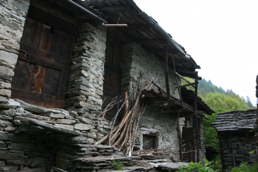
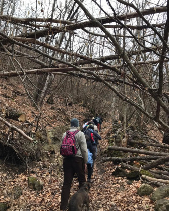
This trail inaugurates a series of itineraries part of the Interreg project InTERRACED - net, a Switzerland-Italy collaboration created to enhance a landscape of great environmental value: the terracing. Among the various types of terracing it will be possible to admire, along this trail, that typical of the Rhaetian slope of Valtellina. These constructions are part of the mountain culture of the area and are evidence of traditional building techniques, the result of unparalleled technical and material knowledge and of the environmental and natural specificities of the place. Viticulture in Valtellina is precisely possible thanks to these ingenious solutions that soften prohibitive slopes and take vines to the limit of their vegetative possibilities, exploiting every available inch of mountain terrain for this crop. In Piazza Matteotti in Ardenno, a crossroads between the road leading to Val Masino and Via Duca D'Aosta leading to the center, the convenience of a public parking lot becomes the starting point of the layout. The Duca d'Aosta municipal street crosses on the left the Calchera street leading to the foot of the slope. Along this road, which climbs slightly, the first terraces can be glimpsed, many of them now engulfed by the forest. This commune is among those that in the past did not fall within the DOCG area, for this reason it is the territory that has lost vineyard area (over 70%) more than others. Along this street one can also admire olive groves that have replaced the vineyards and are responsible for keeping the terrace alive. Arriving at the intersection with Via Cavour, take the latter and ascend among the old nuclei with roofs made of poplar, and then take Via Magiasca, which you follow until you reach Via Cavallari, where the footpath part of the trail begins.The trail crosses the slope vertically, among old terraces planted with vines and olive trees and various fruits, which, intersecting old nuclei, reaches the Gaggio district located at 550 m/slm. It climbs another 150 meters in elevation, crosses the Gaggio stream and enters the municipal territory of Buglio in Monte. The direction of the trail points decidedly eastward and you cross the village of Buglio, located on a magnificent balcony overlooking the plain of the Adda valley. Among old hamlets, meadows and woods, you cross the Primaverta valley to enter the territory of Berbenno in Valtellina.Among ancient maggenghi and chestnut woods, after about 2 km, you arrive at the balcony of the Maroggia district. This is a typical and valuable old contrada, in a partially abandoned state, which gives its name to the subzone "Maroggia." Continue across the Vignone stream and after about 200 m you reach the terraced slope of Monastero. The areas under vines increase and you begin to breathe that air made up of ancient and current labors. After the contrada dei Piasci one continues eastward, among small old nuclei, cultivated spaces with meadows to reach the heart of the terraced area of Berbenno among ancient vineyards, some new plantings and olive trees. Still continuing east among fountains and wash-houses, we cross the old part of the hamlet of Regoledo and take the small road called Credee to begin the path that leads to the Finale stream, where the area of the ancient "Mills" appears, offering a glimpse of a not too distant past.The trail takes us back inside the old district of Polaggia. We continue toward Postalesio among meadows, new vineyards, blueberries and apple orchards and cross the Caldenno stream reaching the small village of Postalesio, then head toward Castione Andevenno. Just above the village of Postalesio you can admire the "pyramids of Postalesio. Castione together with the municipality of Sondrio, Montagna in Valtellina and Poggiridenti represent the heart of the Valtellina wine-growing area, where the best-known and well-known Sassella, Grumello and Inferno production areas are located. From Castione onward to Poggiridenti, one is completely immersed and enraptured by the beauty of the terraces, and the action of man, who has stolen from the rock to cultivate, is perceptible even to the eyes of the distracted. Terraces, old mills, rock carvings, suspension bridges, medieval castles, nothing is missing on this journey immersed in these three docg areas. In the municipality of Castione, and more precisely in the locality of Vendolo, it is possible to visit the "mill of the Rosina" recently restored and open to visitors. From Castione eastward, one travels through the hamlets until reaching the locality of Grigioni, and here begins the journey inside what is considered the most prized area of Valtellina wine production: Sassella. Breathtaking terraces overlooking the valley continue unabated. Before reaching Triasso, on the border between the two municipalities and at the intersection of Via Grigioni and Via Moroni, 200 meters to the west you can visit the "Archaeological Park among the terraced vineyards." The hamlet of Triasso, formerly in the municipality of Sondrio, is worth a visit as it is a village suspended in time, serving viticulture, surrounded by centuries-old chestnut groves and coming to life during the grape harvest in October. Continue along the Sasselle road to the lower part of the hamlet of Sant'Anna. We are in the heart of Sassella and here the panorama enraptures the traveler. We then continue northward reaching the hamlet of Mossini. From 2021, thanks to the construction of the "footbridge over the cassandras" of the Mallero stream, it is possible to reach the locality Ponchiera and find oneself on the vineyards of the "Dossi Salati" in the heart of the Grumello appellation. The new "Tibetan" bridge has become in a short time an attraction destination for tourists who, thanks to the footbridge, have discovered unknown places and corners of vineyards. The "Sassina" inter-farm road crosses the upper part of the Grumello appellation diagonally. The view from the top allows you to see the church of St. Anthony and the famous Grumello Castle. A visit to the castle also allows you to admire the lower part of the Grumello appellation overlooking the Adda valley. Continuing the walk, one arrives in the municipality of Poggiridenti home of the Inferno appellation, which stretches out at the traveler's feet in all its verticality. The border between Poggiridenti and Tresivio is not perceptible because the two municipalities embrace each other, and it is precisely on the border of the two municipalities that the "Santa Casa Lauretana" appears in all its majesty, a church that seems almost "out of tune" for the magnificence and charm it emits. The journey continues through the historic center of Tresivio and, just after the town, the traveler is struck by the intense green of the apple orchards. We are, in fact, traveling to the town of Ponte in Valtellina, a village that first transformed its conoid from meadow to apple orchards in the 1950s, giving birth to the Valtellina apple also known as Melavi.The trail keeps high on the Ponte conoid, through apple orchards and vineyards, and allows a view all the way to the border with Chiuro of the serpentine poplar roofs that characterize this village with its ancient history. A visit to the historic center of Ponte is mandatory. The Val Fontana stream obliges one to travel along provincial road 21, as far as the hamlet of Castionetto di Chiuro, for about 500 meters. Chiuro has always been the wine capital of the valley. The largest wine cellars are concentrated in this area (over 60% of the entire wine production) finds its production here.Just upstream from the village of Castionetto, the "Castionetto Tower", which belonged to the Ghibelline Quadrio family and dates from between the 12th and 15th centuries, is worth a visit.From the hamlet of Castionetto we descend to the Church of San Bartolomeo where our journey through the history and beauty of unique vineyards ends.


 - Villa Melzi d’Eril")