- Itinerari
The colorful plain of Red Prey
Among the most striking places in the Masino Valley is definitely the Preda Rossa plain, an alpine plateau surrounded by sharp rock walls of a typical reddish color and overlooked by the majestic peak of Mount Disgrazia of no less than 3,678 m.
The area is traversed by several streams that create two large marshy areas set a few tens of meters apart. Connecting the two plains, the placid little rivers turn into frothy torrents, eventually flowing into the Duino River, which again pours calmly into the larger plain, drawing sinuous loops among the tufts of grass in the bog.
Admiring from above the shimmering of this watercourse as it slowly flows through the meadows of Preda Rossa is truly a sight not to be missed.
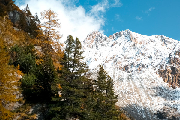
The proposed route can be hiked throughout the year; in winter, of course, a higher degree of caution is required in case of snow. The best time is undoubtedly autumn, from mid-October to early November the plain lights up with the warm hues typical of this season. The yellow and orange larch trees on the mountain slopes, reddish dry grass and snow-sprinkled rocky peaks create the perfect backdrop for those who want to enjoy a colorful mountain show.
To reach Preda Rossa, one must drive to Val Masino (SO), until reaching the village of the same name. From the village, turn right and take the VASP road to Sasso Bisolo/Preda Rossa that leads to the plain.
Access is limited to only 50 cars per day. To travel the road you must have a ticket that can be purchased on the official Val Masino website(https://valmasino.travel).
The road is 12 km long, all paved and fairly well maintained. One must consider that the parking lot is located at an altitude of 2000 m and at that altitude the temperature could be much lower than in the village. Therefore, if you want to visit Presa Rossa in autumn/winter, it is recommended to use winter tires and have snow chains on board, so that you will not have problems in case of icy stretches or snowfall.
To start the hike, you should take the trail marked by red and white trail markers, indicating Rifugio Ponti. The proposed trail is not numbered but the signs are very frequent and clear.
As soon as you pass the first bend to the left, you begin to catch a glimpse of the beautiful snow-capped peak of Mount Disgrazia, which towers over the entire plain and will accompany the hiker throughout the walk.
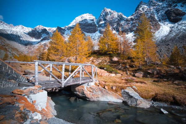
After a few minutes you reach a small wooden bridge located in a truly privileged position and allows you to cross the Diuno River to reach the beginning of the first plain; all this about 20 minutes from the start.
Here the view opens up to an immense clearing of red grass, surrounded by a beautiful frame of larch trees. In the center of the bog, the river flows slowly, although from this position its beauty cannot be fully captured.
The trail in this area forks: signs indicate to continue on the left, while on the right is a second, much wider and flatter section. Given the extreme simplicity of the hike, it is possible to visit both sides of the plain; however, should you choose, the advice is to continue along the left path, as it will then allow you to reach an extremely scenic spot.
We now continue on an almost level path, interspersed now and then with small bridges and wooden footbridges that allow us to overcome the more swampy sections; in fact, although the immense expanse of grass looks like a giant dry meadow, in reality the area hides numerous muddy or stagnant water-filled areas. It is not recommended to leave the marked trail.
When you reach about halfway through the first plain, a sign indicating a viewpoint on the left is clearly visible. This slight detour requires only 10 minutes of walking on a much steeper trail than the one taken so far. As you ascend you quickly gain many meters of elevation gain and upon reaching the end of the section you come to a small wooden balcony with a couple of benches.
From up here one becomes more aware of the size of the plateau and is finally able to distinguish in its entirety the beautiful course of the Duino River: a soft brushstroke of turquoise blue that stretches, with wide curves, over a carpet of red grass. This is probably not the most striking point of the hike but, for the small effort required, it is absolutely worth it.
Once down you continue along the main trail, which is always very flat and very easy to walk on. Upon reaching the end of the grassy area, the trail begins to climb quite steeply following the course of the river within a beautiful forest.
At last the orange of the larches, which we could only see in the distance before, is at hand and the landscape changes accordingly. All along the ascent the grass gives way to large rocks, the calm flow of the river turns into a rushing torrent full of small waterfalls, and the snowy peaks are now hidden by tree branches.
The ascent is not complex, in fact it is only 150 m of elevation gain, however, the section definitely turns into a classic mountain trail with a fairly uneven bottom and full of stones and roots sticking out. For the youngest or for those who are not used to it, the end of the first plain might therefore already be a good point to end the hike. For everyone else, however, the advice is to make this last effort to reach the second plateau of Preda Rossa.
It continues through the forest at a fair gradient, tackling several very narrow switchbacks and climbing up several natural rock steps. The stream, although always close to the beaten path, never encroaches on the hike area, thus avoiding the risk of slippery areas. During the ascent, the advice is to turn continuously to be able to catch those glimpses that manage to give the best view of the plain just passed. In fact, there are several viewpoints along the trail where the vegetation becomes a little sparser and the view sweeps over the entire stretch just crossed and the flow of the river.
The climb takes about 30 minutes, but the several breaks to admire the view could make it considerably longer.
Once the ascent is completed, the trail becomes flat again, grass again becomes present over the entire area, albeit with a slightly darker color, and the riverbanks finally become easily accessible without the risk of sinking into the mud.
The second plain is a bit smaller than the first, not walkable in its entirety, and the colors tend to fade a bit. However, the view of Disgrazia and the surrounding mountains improves incredibly: it almost seems as if you can quickly overcome those steep slopes and then touch the snow covering the sharp peaks surrounding the plateau.
The advice is to roam freely throughout this area: there are several sections of trail that allow you to reach the banks of the various branches of the small rivers, a small wooden bridge that allows you to cross the widest section, and with each step new vistas open up of the surrounding mountains. In addition, in this area the grass is dry and there are several boulders on which to sit and have something to eat.
The hike ends right on the second plain. In the area there are no resting places to eat or even drinking fountains. The nearest shelter is the Ponti, but throughout the fall and winter months it is closed. Therefore, in order to have a picnic, one must carry everything necessary in one's backpack.
The descent is made along the same route as the outward journey. There are no dangers even along the steepest section, the only risk is to want to stop again, because of a view to admire, not seen during the ascent.
In the case of very young children or those not used to walking, it is advisable to limit oneself to the tour of the first plain, avoiding the climb to the second one and to the viewpoint (1.2 km total and an elevation gain of only 50 m). For those who are more familiar with walking in the mountains, however, the two climbs will not be a problem at all and will add beauty to the hike.
-
Ph: Stefano Poma
Mostra cosa c'è nelle vicinanze:


