• Active & Green
    • Cycle Tourism
    • Sport

Cycling from Aprica to Val Belviso

Highest point 2320 m
Total elevation gain 1550 m
Total elevation loss 1550 m
Total climb 18 km
Total descent 16,5 km
Total distance 25,4 km
Duration 6-8 h
Cycling rate (%) 80%

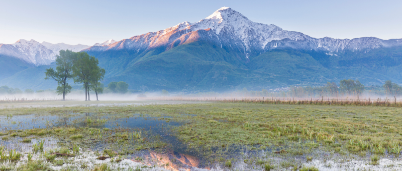
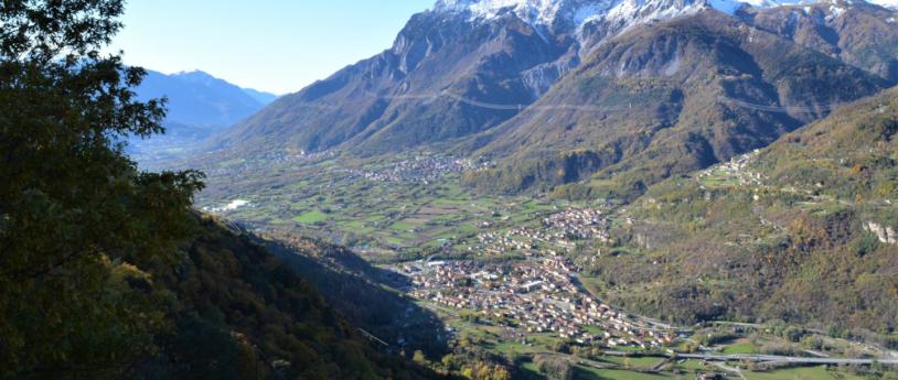
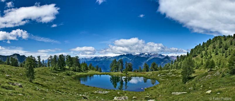
This route extends wholly through a valley belonging to the Orobic Alps.  Val  belviso  is  the  last  eastern  valley,  it  is  long,  deep  and  nar-row, but along the path going south from Alpe Magnolta to Passo di Venerocolo it seems bright and wide. The outline of Monte Torena  –  the  last  high  peak  of  Orobic  Alps  –  dominates  the  other  side  westwards reflecting its shape into the waters of the huge artificial lake on the valley bottom. Once you get to the pass dividing us from the  Province  of  bergamo,  you  will  find  some  alpine  lakes  wedged  among  the  rocks  and  the  grassy  small  hills.  The  descent  runs  on  a  trail at first and then turns into a dirt road through the whole valley, both alongside the lake and under the dam. In San Paolo the Rifugio Cristina is a nice place to grab calories and shelter. You can  start  from  the  car  park  nearby  Magnolta  ski  runs  and  take  the dirt road climbing up to the left of the cableway. The sign indicates  Malga  Magnolta  and  Passo  Venerocolo.  You  can  easily  cycle on the first half of the uphill dirt road, which then gets much steeper  from  the  mountain  huts  in  Corna  Alta  (1457  m)  to  the  finish  of  the  cableway  (1870  m),  so  that  you  may  need  to  carry  your  MTb.  This  is  a  challenging  ascent  but  in  summertime  you  can  use  the lift up to Magnolta. Halfway up the second ski lift, at 1940 meters, the track becomes a flat trail, which goes into the wood, turns south and enters Val belviso. you have to ride for about 13 km on a flat path going sometimes gently uphill, going past Malga Magnola (1997 m) and crossing the Valle del latte and the Valle di Pisa.  You have  to  pay  attention  to  some  exposed  stretches.  The  first  part  of  the  descent  from  Passo  di  Venerocolo  (2314  m)  to  the  dirt  road  at  2000 meters above Malga di Campo (1816 m) is steep and not very flowing. The downhill ride alongside the artificial lake and through the  remaining  part  of  Val  belviso  does  not  hinder  your  fun.  The  route ends with the ascent on a paved road from Ponte Ganda (906 m) to the resort town of Aprica.


Other links

In bicicletta da Col d'Anzana alla Val Fontana

On the same topic

Bergamo Valle Imagna, a jewel just waiting to be discovered

A tiny natural jewel that still today preserves all the spirit of life in the mountains and the good flavours of food
  • Active & Green
Bergamo Valle Imagna, un tesoro tutto da scoprire

Up and down on a funicular: the panorama seen from the sky

Lombardy funiculars: the most romantic means of transport man has created
  • Active & Green
Up and down on a funicular: the panorama seen from the sky

Gardens Monza

Relax and nature among the rose gardens in Villa Reale of Monza and in the parks of the province.
  • Active & Green
Mete verdi lombardia

Discovering the lavender fields in Oltrepò Pavese

Not just Provence: lavender fields can also be found in Oltrepò Pavese.
  • Active & Green
Discovering the lavender fields in Oltrepò Pavese

Picnics in Lombardy

8 easy picnic places in Lombardy: On the beaches of our lakes, in the cool of the woods, or in the company of dinosaurs!
  • Active & Green
panorama sondrio

Discovering Lombardy with Va' Sentiero along the Italy Trail

  • Active & Green
Admiring the view from Pizzo Scalino, Valtellina, Lombardy

Mountain flowers in May

Six itineraries to discover this month's flowers in the mountains of Lombardy
  • Active & Green
Fiori di maggio ad alta quota - in Lombardia

Gardens in Lombardy

The botanical gardens of Lombardy are real jewels to visit, so come on, what are you waiting for?
  • Active & Green
Gardens in Lombardy, discover what to see

The High Route of Valmalenco – 7th stage

Rif Bignami (2382 m) - A Gembrè (2190 m) - A Val Poschiavina (2230 m) - Passa Canciano (2464 m) - Passo Campagneda (2601 m) - Rif. Cristina (2227 m)
  • Active & Green
Diga di Alpe Gera

Between the Ticino and Po rivers

Alla scoperta di acque e castelli in provincia di Pavia
  • Active & Green
Between the Ticino and Po rivers

Po, a river to experience.

The italian longest river offers you unforgettable moments.
  • Active & Green
Gita fuori porta a Cremona lungo il Po

Monumental trees in Lombardy

The art of knowing trees in Lombardy
  • Active & Green
Alberi monumentali in Lombardia

The high route of Valmalenco - presentation

The high route of Valmalenco is a trekking of 8 stage, around 110 km.
  • Active & Green
The high route of Valmalenco - presentation

Action sports in Lombardy

From Lake Garda to Val Brembana, 5 action sports destinations offering a hefty dose of adrenaline
  • Active & Green
Action sports in Lombardy

Where to keep cool in Lombardy

If you are looking to cool down a little in the summer heat, here are a few suggestions.
  • Active & Green
Where to keep cool in Lombardy

Valmalenco sports centers

Valmalenco offers all nature lovers and sports enthusiasts various facilities-sports centers, each with its own special features.
  • Active & Green
Valmalenco sports centers

The 10 best panoramic viewpoints in Oltrepò Pavese for incredible photos

  • Active & Green
The 10 best panoramic viewpoints in Oltrepò Pavese for incredible photos

Autodromo di monza

Monza and Formula 1 are two excellences of Motorsport.
  • Active & Green
Autodromo Nazionale Monza

Discovering the Big Benches in the province of Pavia

How to reconnect with childhood by rediscovering the landscape with the Big Benches!
  • Active & Green
Big Bench in provincia di Pavia

The Salt Route

From Varzi to the sea
  • Active & Green
Via del Sale